Although there are three large dams on the Boise River, it is still subject to flooding. Flows have reached or exceeded the 7000 cubic feet per second (cfs) flood stage ten times since 1982. Flows reached 9840 cfs in 1983, and 9590 cfs in 2017. Many people are impacted when this occurs. Most homeowner’s policies do not cover floods.
Flash flooding is a deadly natural hazard. Certain gulches in Ada County, including Cottonwood, Hulls, Crane, and Stuart, pose a flash flood threat.
Current Boise River Flow Rate At Glenwood Bridge
Discharge,ft3/s |
Date |
Time |
|---|---|---|
| 510 | 2024-09-20 | 12:45 MDT |
Credit: U.S. Geological Survey
Department of the Interior/USGS
Boise River Flood Inundation Maps
These two interactive maps depict fifteen different flow rates of the Boise River from just below Lucky Peak Dam to the Ada/Canyon County border. The flow model used provides the best analysis of flooding and flood depths that it can. However, high water events are dynamic and flood waters could end up in areas not depicted on the map. The flood inundation map contains large amounts of information. Computer performance and internet connection speeds may affect the map’s ability to display all of the flows.
Interactive Boise River Flood Map(Diversion Dam to Eagle Island)
Interactive Boise River Flood Map(Eagle Island to County border)
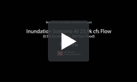
Google Earth Fly thru depicting the Boise River flowing at 23,900 cfs. (200 year Flood Event) based on a computer flood model.
These maps are for planning and awareness purposes only and are not the regulatory Flood Insurance Rate Map (FIRM).
Lending institutions that are federally regulated or insured require flood insurance on properties that are located in areas at high risk of flooding. The FEMA Flood Hazard map clearly delineates if properties are in a Special Flood Hazard Area (SFHA). To check a property’s flood status, type the address in the search query box of the FEMA Flood map located online at: FEMA National Flood Hazard Map
This 9 minute video seeks to educate 4th-6th graders about the Boise watershed, where their water comes from, and the many uses of that water in the Treasure Valley. Produced in partnership with the Natural Resources Conservation Service Snow Survey, Boise WaterShed Environmental Education Center, and Bogus Basin Snow School.
Flood Preparedness Resources
 Flood Insurance Claims Handbook
- Flood Insurance Coverage FAQ
- National Flood Insurance Program Coverage Summary
- Flood Loss Estimations (2017)
- What Goes Into A Flood Map – FEMA Infographic
- Buy Flood Insurance Rate Maps from FEMA
- Flash floods & Insurance
- FloodSmart.gov – Flood Insurance Information
- Idaho Department of Water Resources Flood Map Server
- American Society of Home Inspectors Flooding Advice
- Are You Ready for a Flood or Flash Flood?
- Are You Ready for the Flood?
- Flood Preparation & Safety Brochure
- Flood Safety Checklist
- How To Use Sandbag
- Idaho Floods! A Flood Awareness Guide for the Gem State
- Living With Dams (FEMA)
- Mold & Mildew in Your Flood Damaged Home
- Idaho Department of Water Resources
| Date | High Flow (in cfs) for Year |
| 4/30/06 | 7,440 |
| 7/23/07 | 1,670 |
| 5/20/08 | 7,270 |
| 6/7/09 | 6,320 |
| 6/12/10 | 6,000 |
| 5/18/11 | 7,230 |
| 5/5/12 | 8,310 |
| 5/21/13 | 1,520 |
| 3/21/14 | 2,130 |
| 5/19/15 | 1,770 |
| 4/11/16 | 6,420 |
| 6/6/17 | 9,590 |
| 5/28/18 | 6,520 |