

Western Foothills
228 acres are reserved from the Ada County Landfill property for open space and trails.
The Seaman’s Gulch area includes One parking area for 10-14 cars and two horse trailers. Approximately 3 miles of non-motorized trails. Similar to Barber Park, the site is managed by Ada County Parks and Waterways.
Hubbard Reservoir


Hubbard Dam
Located about 12 miles southwest of Boise, Idaho was originally constructed in 1902 by private interests. The Bureau of Reclamation purchased the facility in 1911 as part of the Boise Project. This is an earth fill structure 23 feet high creating a reservoir area of 450 acres with an active capacity of about 4,000 acre-feet. Water is delivered to the reservoir by the New York Canal. The dam and reservoir are operated and maintained by the Boise Project Board of Control as a re-regulating facility for irrigation water deliveries in the adjacent area. It also provides emergency short-term storage for de-watering the New York Canal should a failure in the canal occur downstream.
Geology
Hubbard Dam is centrally located in the Western Snake River Plain (WSPR) physiographic province. The WSRP is a 50 to 70 km wide trough that trends northeast across southwestern Idaho. The WSRP is characterized by mid to late Cenozoic fluvial lacustrine sedimentation, voluminous basaltic volcanism, low relief and extremely low rates of seismicity.
Friends of Hubbard Reservoir
The goal of Friends of Hubbard Reservoir (FOHR) is to elevate the public’s awareness of the vast potential held by Hubbard Reservoir. FOHR encourages local government, business, schools, and citizens to donate funds and time to improve the accessibility to and use of the site. There is enormous potential here for a beautiful nature preserve, strategically located in the middle of what will eventually be large housing developments.
Oregon Trail Trailhead


The Historic Oregon Trail has a trailhead and interpretive kiosk it is located on SH-21. You can enjoy hiking, mountain biking, bird-watching, and equestrian riding to access the Oregon Trail ruts to the Boise River. Upriver you can access Lucky Peak Recreation area and Bonneville Point.
Victory and Five Mile Wetland Area
Boise Urban Wetland Restoration: Five Mile/Victory WetlandWhat was done and why?
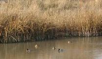
The Five Mile/Victory Wetland (Site) was originated in 1996 when the USDA Natural Resources Conservation Service (NRCS) wanted to build a site to demonstrate the value of surface water retention rather than the common pipe and burial methods used in so many residential developments. The land chosen for the project was originally owned by the Ada County Highway District (ACHD), which they used as a stormwater runoff retention basin. According to the NRCS, this site was essentially a “weedy mess” that contained old tires, broken-up concrete, and 7-ft high Canada thistle. The site consisted of a 1.3 acre, narrow strip of land in a natural drainage of an urban Boise subdivision. Retaining most of the slow-moving water, was a broken and rundown concrete structure. Downstream of this consisted of a backhoe “sluice box” to direct the water flow.
The goals of the Five Mile/Victory Wetland were the following:
- Increase wildlife habitat and use
- Improve water quality (especially stormwater runoff containing petrochemical constituents)
- Demonstrate wetland benefits to city developers and private consultants
- Educate elementary school children and high school and college students to the benefits of wetlands, through the use of interpretive signs and an interpretive trail.
- Increase local property values
- Restore and refurbish native vegetation
- The Ada Soil & Water Conservation District and USDA-NRCS began a plan to convert this neglected area to a restored wetland in 1996. The project, which was a voluntary wetland construction effort rather than a mitigation plan, was funded by grants. Project construction costs totaled $44,000, which does not include in-kind contributions from the NRCS and volunteers. To all those involved, especially the adjacent homeowners, the project has been a great success for urban wetland restoration.
Who was involved?
USDA Natural Resources Conservation Service, Ada County Soil Conservation District, Ada County Parks and Waterways, Ada County Commissioners, Ada County Highway District.
Boise River Trails Coalition
THE VISION
Our Vision is to have a connected system of pathways on land and water on and near the Boise River from Lucky Peak Dam to the Snake River that binds the recreational, educational and economic opportunities of our river communities.
THE COALITION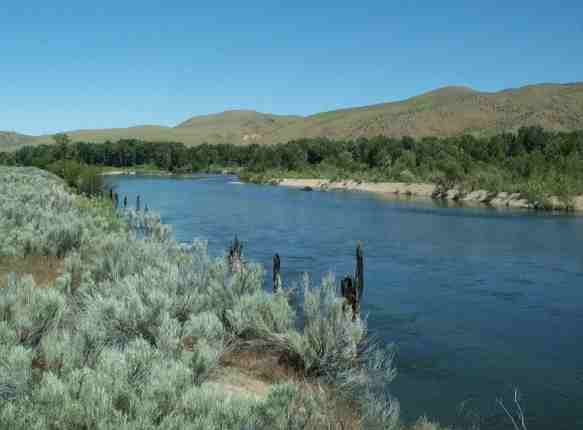
The Boise River Trail Coalition is made up of a cross-section of Treasure Valley citizens and representatives of cities, counties, and non-profit organizations.
The Coalition is funded thru a grant received from the National Parks Service and is facilitated by Sue Abbott, a National Park Service planner, based in Seattle, Washington. The Coalition meets monthly on the 2nd Wednesday of the month. Location rotates among members.
OUR GOALS
- Create a land and water trail system that will be supported by community participation.
- Design connected pathways for community walking, bicycling, horseback riding, bird watching, river paddling, fishing, and other non-motorized outdoor activities.
- Connect community trail networks with alternative transportation routes.
- Respect the rights of private landowners and the wishes of donors to the pathways system.
- Promote the health and wellness benefits of Boise River Trails to Treasure Valley residents and visitors.
- Provide educational opportunities and interpretation of the natural and cultural resources along the land and water trails.
- Promote the economic development of Boise River communities through partnerships, programs, and facilities.

Ridge to Rivers
With over 125 miles of trail, there is something for everyone in this labyrinth of trails. Check out the Ridge to Rivers Website for great trail information, up-to-the-minute news and trail tips.